Penobscot Bay Floods the Wildlands
IMAGINE…
When we look around the Wildlands and the coast of Maine now, what we see is very different from what was thousands of years ago. To be more specific, approximately 25,000 years ago, the coastline was actually somewhere between 250 and 300 feet lower than it currently is. This was due to the large mile-high glacier covering the State of Maine at the time. The weight of this ice sheet caused isostatic depression of the crust.
Once the ice began to retreat roughly 21,000 years ago, the glacial front reached the present-day Maine coastline by 17-16,000 years ago.
As the glacier continued to recede,the rebounding crust began to rapidly re-define Maine’s coastline and present-day watersheds about 12,000 years ago. This process is still happening today, although at a much slower rate.
Geology in the Wildlands
Much of the Wildlands and the Valley Road of today would have been under water…Great Pond Mountain and several other landmarks of the park would have been islands surrounded by the sea. Fine silt from the glacier as well as washed sand from the sea water would have left marine mud and fossils in the river channels and bays which geologists have named the Presumpscot Formation and has been found in the channels and bays of the Penobscot River basin. One can also note that the location of the Valley Road closely follows the 300 ft glacial-marine border, which might explain why native sand and gravel deposits along this marine border would have been the likely site for the original human pathways and, later, the road byways of today.
Once the glacier fully melted, and with time, the land rebounded and turned the river flow back toward the current sea and revealed the current landscape of the Wildlands.
“Around 16 – 15,000 years ago, which marks the last period of glacial retreat in the Penobscot lowland area (reference), meltwater coupled with crustal submergence essentially reversed the flow of our rivers. The ice sheet had temporarily re-contoured Maine and in its absence, the sea flowed inland toward the center of the bowl, flooding the coastal waterways up the Penobscot, Kennebec and Androscoggin” – Leah Page, Consulting Geologist
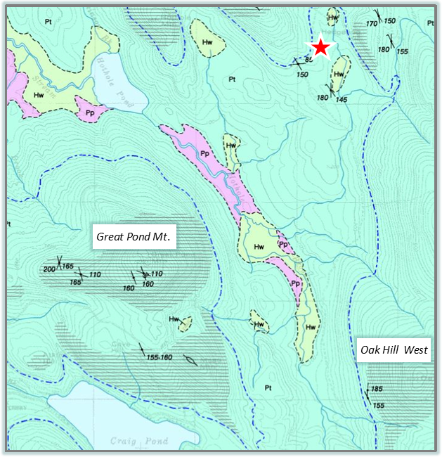
Surficial Geology Map
Notice the labels for the Great Pond Mountain and Oak Hill West summit. For more on the Surficial Geologic History of Maine, visit Maine Geological Survey.
Maine’s “Blue Clay” – The Presumpscot Formation
The Presumpscot Formation is a glacial deposit that formed during the last ice age and is made of predominately submarine clays. This unit formed when the glaciers were melting and their margins retreating away from the present-day ocean. The glacier receded to about where the present-day coast of Maine is 16,000 years ago. In response to the weight of the large glacier, the earth’s crust was pressed down allowing the ocean water to flood into the Gulf of Maine and coming in contact with the glaciers ice.
This sea continued to flood inland as the glacier retreated. The sea waters went up rivers and flooded lowlands since the earth’s crust had not yet responded from being free from the weight of the ice sheet.
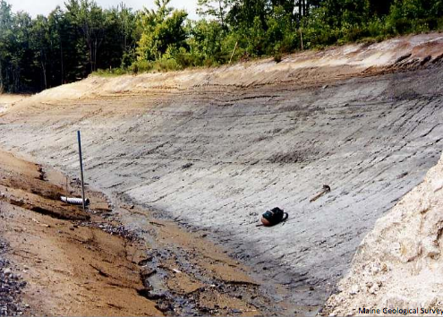
Glaciomarine mud
Notice the color changes along this stretch of cut road that exposes light gray marine clay. Photo by Thomas K. Weddle , from Maine Geological Survey. For more information on the Presumpscot Formation, visit Maine Geological Survey here.
Additional sources:
https://sites.google.com/site/earthscienceinmaine/erosion-and-deposition-by-glaciers
https://digitalmaine.com/cgi/viewcontent.cgi?article=1366&context=mgs_publications
https://www.maine.gov/dacf/mgs/explore/surficial/facts/surficial.htm
fossils — https://www.maine.gov/dacf/mgs/explore/fossils/sediment/fossil-sed.htm
Trail Activities
Learn more about Geology with the Nature Hand Book! This Hand Book highlights the Settlement Quarry on Deer Isle, Maine! This site, as well as the Wildlands, is a great example of the Geological History of Maine! Click for a PDF of the Handbook below.
